

Turbulence is a prominent topic in aviation that has recently garnered even more attention worldwide, with an increased frequency of extreme events making national headlines across the world.
With many fliers naturally anxious about this hazard to flying, this article will help explain what turbulence is, what causes it, and why it appears to be getting worse.
What Is Turbulence?
Officially defined, turbulence is “A violent or unsteady movement of air or water, or some other fluid”. As we are on the topic of aviation, only air turbulence will be covered. Specifically in that realm, there are two main sources of turbulence for an aircraft, cloud/thunderstorm-induced turbulence and clear air turbulence.
Both are equally hazardous, and have the potential to cause damage to aircraft if not avoided or exited upon encountering it. Turbulence can be rated across a multitude of categories, from as small as a light chop, all the way up to extreme turbulence, which by definition states “the aircraft can be out of control at all times”.

These extreme occurrences are the ones that make the news most often, and while very important to know about, can sometimes put a bad perspective on just how bad turbulence is *most* of the time.
Cloud Related Turbulence
When most people think of turbulence, they associate it with the visual presence of clouds. Multiple forms of cloud turbulence exist, but the main and most common type is produced through thunderstorms.
In those storms, there are strong updrafts and downdrafts within the cloud, and these strong movements of air opposing each other create turbulence producing shear. This shear turbulence associated with thunderstorms can be experienced several thousand feet above and up to 20 miles laterally from a thunderstorm.
Also produced from thunderstorms are gust fronts, which are lines of strong winds propagating out from the front of a convective development. It causes a rapid, and sometimes drastic, change in surface wind ahead of a thunderstorm.
Visually, these appear in the form of a “roll cloud” which, as it sounds, appears to be rolling as it moves forward ahead of the main precipitation core of a thunderstorm.
Roll clouds can be up to 15 miles ahead of the storm, and usually contain some of the most extreme turbulence that can be encountered in a thunderstorm, but it is worth noting that due to the low-level nature of gust fronts, they are confined to altitudes closer to ground level, rather than throughout the vertical build of the storm.

Mountain wave turbulence is another type of turbulence associated with clouds. It is characterized by similar roll clouds like a gust front, but these clouds are stationary on the leeward (back side) of a mountain.
As wind rolls up and over the front face of a mountain, the landmass itself interrupts the flow of air across that area, and causes an interruption behind the mountain, causing the air to have a wavelike rolling pattern.
These waves are where mountain wave turbulence gets its name, and this is what causes the leeward side roll clouds to form. However, since it always forms around the vicinity of mountains, aircraft are rarely (if ever) flying in these areas, and thus results in minimal encounters with this type of turbulence.
Clear Air Turbulence
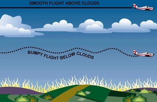
Moving away from turbulence produced by clouds, we must now cover the more dangerous and unpredictable clear-air turbulence, which is the culprit of most of today’s recent severe turbulence news stories.
Similar to the dynamics of thunderstorms and cloud-induced turbulence, clear air turbulence is formed when updrafts and downdrafts create strong shearing moments in the atmosphere. In addition, gravity waves within the atmosphere are built up from these shear moments, and in a stable layer of the atmosphere, these waves can “break” and cause the disrupted air that aircraft encounter.
Clear air turbulence can vary from a light chop all the way up to extreme, and is generally seen anywhere between 20,000 feet and 49,000 feet.
Unlike thunderstorms, clear air turbulence is much harder to forecast, simply because of its nature to be invisible to the naked eye and onboard aircraft instruments. It can be predicted, but there are limits to the ability of that prediction, and the best tool that air traffic control uses isn’t even an instrument at all.
It’s simply reports from other pilots. When pilots report what is in the area, ATC can work other flights above, below, or around what has been reported by previous flights (with some limitations that are mentioned further below).
It also allows ATC to sample other regions of air that might have also had predicted turbulence, to see if the predictions were right or not. This domino effect of receiving and testing information is what allows most flights to avoid clear air turbulence when possible.
Is Turbulence Getting Worse?
Turbulence, while portrayed by most news outlets as something that is getting worse, is not really any more of a problem now than it was before.
It simply has to do with the fact that air travel is an industry that continues to grow, and it means that more and more aircraft are in the sky at any given time throughout the world, resulting in more frequent turbulence encounters.
Airplane manufacturers go through a rigorous testing program for fuselage design and wing loading, and most aircraft in commercial operation today are designed to take wing and structure load factors near 200% of what they are certified for in regular daily operations.
In addition, air traffic controllers and aviation weather forecasters are always trying to keep as many aircraft on favorable routes. Even the pilots are looking out for the well-being of their own passengers. But sometimes with airspace congestion, it’s not possible to avoid light to moderate turbulence that poses no risk to the overall safety of the aircraft and the flight.
As a pilot in training, I was able to hear a congestion issue firsthand on a cross-country night flight. It was over Arizona at night, where light chop clear air turbulence was covering altitudes between 28,000 feet and 40,000 feet.
Many aircraft were requesting higher and lower altitudes in that range to see if they could get a better ride, but with the amount of aircraft in the coverage range of the controllers I was listening to, there was just too much congestion to allow any flights to test out other altitudes.
Of course, that is turbulence that is manageable, and at most serves as a nuisance to a smooth ride rather than an outright emergency.

If severe or extreme turbulence is encountered, ATC will give priority handling to get aircraft out of situations that could result in injuries to anyone onboard, especially those of flight attendants who may be out in the aisles when an unexpected clear air turbulence event occurs.
As a last resort, the pilots in command of an aircraft can also deviate from course if the threat to flight safety is at hand.
The Main Takeaway
The point is, that the safety of the flight, along with the welfare of the crew and passengers is the outright priority whenever any turbulence is encountered.
So much is done by pilots to ATC and even weather forecasters to predict, observe, and avoid turbulence, we should be appreciative that generally, only light to moderate turbulence is encountered when flying.
But know that in today’s world of aviation, any type of turbulence is possible at any time, and serves as a reminder to always have your seatbelt fastened whenever you are seated during a flight.
The Long Way Home: Boeing's 777X Nears Certification at Farnborough 2026, And Boeing Already Wants It to Fly Even Farther » LaGuardia Tower Alerts Pilots to Possible Shoulder-Fired Missile Threat Near Airport » The UK Is Building Its Own AI, and Defense Giants Are All In »

Comments (0)
Add Your Comment
TAGS
INFORMATIONAL turbulenceflightbumpsclearairturbulencethunderstormsweatherRECENTLY PUBLISHED
 airBaltic Launches Swiss Subsidiary to Expand Pilot Employment and ACMI Operations
airBaltic sets up a Swiss subsidiary to employ pilots under local contracts, supporting its growing international ACMI wet-lease business.
NEWS
READ MORE »
airBaltic Launches Swiss Subsidiary to Expand Pilot Employment and ACMI Operations
airBaltic sets up a Swiss subsidiary to employ pilots under local contracts, supporting its growing international ACMI wet-lease business.
NEWS
READ MORE »
 Southwest Airlines Partners With Chase to Launch Co-Branded Airport Lounges
Southwest Airlines confirms plans to open premium airport lounges co-branded with Chase, marking a major shift for the traditionally no-frills carrier.
NEWS
READ MORE »
Southwest Airlines Partners With Chase to Launch Co-Branded Airport Lounges
Southwest Airlines confirms plans to open premium airport lounges co-branded with Chase, marking a major shift for the traditionally no-frills carrier.
NEWS
READ MORE »
 SWISS A330 Bound for New York Diverts to Bangor After Smoke Fills Business Class Cabin
A SWISS Airbus A330 flying from Zurich to New York made an emergency landing in Bangor, Maine, after smoke filled the business class cabin.
NEWS
READ MORE »
SWISS A330 Bound for New York Diverts to Bangor After Smoke Fills Business Class Cabin
A SWISS Airbus A330 flying from Zurich to New York made an emergency landing in Bangor, Maine, after smoke filled the business class cabin.
NEWS
READ MORE »
More than just headlines.
Get unlimited ad-free access to in-depth aviation news, premium stories, and exclusive insights other sites don't cover.
- Ad-free browsing on AeroXplorer
- Unlimited access to premium and exclusive articles
- Higher photo upload limits & commissions on sales
- Free access to Jetstream Magazine on higher tiers
- Ad-free browsing
- Sell aviation photos with 60% commission
- First week free!
- Everything in Basic+
- Unlimited premium articles
- Sell aviation photos with 70% commission
- Free Digital subscription to Jetstream Magazine
- First week free!
- Everything in Basic+ and Pro
- Sell aviaiton photos with 80% commission
- Early access to exclusive stories
- Free Digital+Print subscription to Jetstream Magazine